
2013年04月27日
沿岸航路
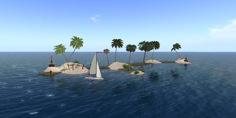
外洋をヨットで走る場所を探しました。SLのヨットは「沿岸限定」なので(^-)、青い線から沖へは出られません(SIMがない;;)
ここは私たちが住んでいるノーチラス大陸の北の端です。リンデンの用意した「沿岸航路」の一部で、誰でもヨットが出せる場所が用意されています。
Looked for sea areas for outer sea sailing. Since yachts in SL are ‘coast only’, it is impossible to sail out of the blue line (there is no SIM.) This is the North end of Nautilus continent where we live. This is a part of ‘Coastal waterway’ prepared by Linden and there are several public rez points.

スタート地点は小さな島。もちろんこっちをゴールにしてもいいんですけど、目標としては貧弱。
ヨットで走る場合は風向風速を自分で設定するか、自然の風(SIM風)を使います。
WildWindのヨットではコマンドは、wind lock, wind dir, wind spd。例えば、/1 wind dir 0, /1 wind spd 10。
SIM風は遅いし凪いでしまうこともありますが、のんびり風待ちしながらのセイリングも楽しいでしょう。
Start: http://slurl.com/secondlife/Vipiteno/39/41/21
The start point is a small island. This point can be used as a goal but a bit poor for the target. When sailing, you can set the wind yourself or use natural wind (SIM wind). If you use yachts by WildWind, the commands are ‘wind lock’, ‘wind dir’, and ‘wind spd’. For example, /1 wind dir 0, /1 wind spd 10, etc. SIM wind is slow and lull sometimes, but it could be also interesting to sail waiting for the wind.
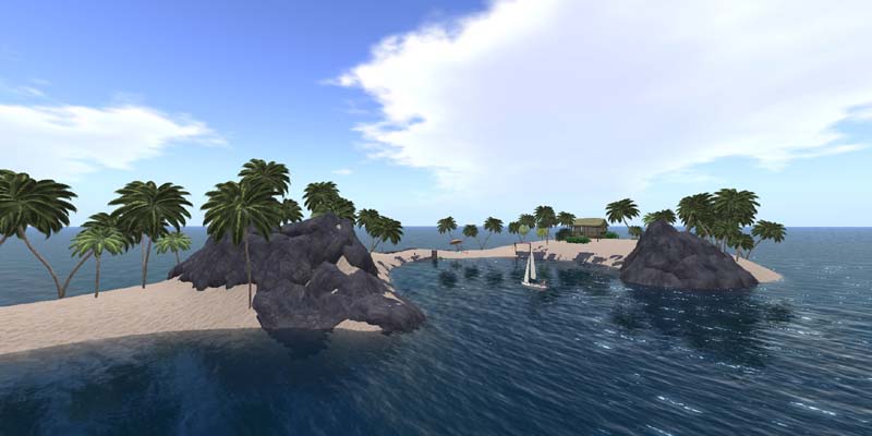
8分ほどの航海ですが、目的の島が見えてきて、最後のSIM境界を無事に超えられた時は嬉しい!
海岸のSIMには立ち入り禁止や落ちる場所があるので、一番上の図の赤線には接近しない方がいいみたいです。
ゴールは一般に公開されている無人島で砂浜は自由に使うことが出来ます。デートスポットとしても(^-)
ヨットを自由に出せる場所は、検索でboat rezでいくつか出てきます。
Goal: http://slurl.com/secondlife/Kenosaki/147/186/22
It is only about eight minutes sailing, but it is exciting when the target island comes in sight and crossed the final SIM border without incident. There is some seaside-SIM that is off-limit or causes freezing, so it had better not enter the red lines in the top picture. The goal island is an island open for public and the facilities are free to use. It could be good for a date spot… Other free yacht rez point can be found by searching with “boat rez”.
ノーチラス大陸の全景。上のコースが矢印部分。私たちの家があるのは西の端。前回紹介したKazumiさんとこのコースはその右の内海。
ノーチラスは5番目に出来た大陸で、最初はヨットが走れるよう水面が多かったのだそうです。
海岸地区の住人のご好意で自由に通過できた海も埋め立てや立ち入り禁止が多くなってしまいました。
「大陸」とはいうものの幅は約SIM30個、8km弱しかなく、伊豆大島の半分くらいの島です。
Total view of the Nautilus continent. The arrow shows the above course. Our houses are on the west side. The course at Kazumi’s pier that was introduced last time is in the inland sea seen on the left. The Nautilus continent was the fifth land. At the first time, it had many water surfaces for sailing and shoreline SIMs can be passed freely by the courtesy of the residents, but recently many places became landfilled or off-limits. Although it is called ‘continent’, the width is only about 30 SIMs wide, less than 8km that is about half size of Izu-Ohshima.

SLの大陸群。ノーチラス大陸の北がコルシカ大陸ですが、RLのコルシカ島には似てないし半分位しかない。
この地図で海のように見える青い部分にはSIMがないので通れません。
大陸間移動が可能なのは右の4つと、左の2つだけのようです。次回に挑戦!
The continents of SL. There is no SIM in the blue area in this map and it is impossible to enter. Moving from a continent to another one is only possible with the right four SIMs and left two. I will challenge it next time.

SLの全世界。白く見えているのが上の図の大陸群で、西側には独立SIMが散らばっています。
私が青い線で囲った少し色の濃い部分は何なのでしょう。 SIMをこれから置くことが出来るエリア? なぜこんな形に?
全世界の幅は約300km、関東平野くらいの広さです。
狭いとも言えますけど、東京、横浜などの建物から畑や山まで、関東平野全部をリアルにモデル化することを考えたら凄いですよね。
The whole SL world. The white ones are the continents shown above. There are many independent SIMs scattered on the left. What does the dark area that I eclosed with blue lines? Is it reserved for future SIM setting? Why is it shaped like this? The width of the total area is about 300km that is as same as the Kanto Plain, The world could be considered small, but it is amazing to imagine that it is equicalent to make all buildings in cities, houses, and fields in the whole plane realistically modeld.

ここは私たちが住んでいるノーチラス大陸の北の端です。リンデンの用意した「沿岸航路」の一部で、誰でもヨットが出せる場所が用意されています。
Looked for sea areas for outer sea sailing. Since yachts in SL are ‘coast only’, it is impossible to sail out of the blue line (there is no SIM.) This is the North end of Nautilus continent where we live. This is a part of ‘Coastal waterway’ prepared by Linden and there are several public rez points.

スタート地点は小さな島。もちろんこっちをゴールにしてもいいんですけど、目標としては貧弱。
ヨットで走る場合は風向風速を自分で設定するか、自然の風(SIM風)を使います。
WildWindのヨットではコマンドは、wind lock, wind dir, wind spd。例えば、/1 wind dir 0, /1 wind spd 10。
SIM風は遅いし凪いでしまうこともありますが、のんびり風待ちしながらのセイリングも楽しいでしょう。
Start: http://slurl.com/secondlife/Vipiteno/39/41/21
The start point is a small island. This point can be used as a goal but a bit poor for the target. When sailing, you can set the wind yourself or use natural wind (SIM wind). If you use yachts by WildWind, the commands are ‘wind lock’, ‘wind dir’, and ‘wind spd’. For example, /1 wind dir 0, /1 wind spd 10, etc. SIM wind is slow and lull sometimes, but it could be also interesting to sail waiting for the wind.

8分ほどの航海ですが、目的の島が見えてきて、最後のSIM境界を無事に超えられた時は嬉しい!
海岸のSIMには立ち入り禁止や落ちる場所があるので、一番上の図の赤線には接近しない方がいいみたいです。
ゴールは一般に公開されている無人島で砂浜は自由に使うことが出来ます。デートスポットとしても(^-)
ヨットを自由に出せる場所は、検索でboat rezでいくつか出てきます。
Goal: http://slurl.com/secondlife/Kenosaki/147/186/22
It is only about eight minutes sailing, but it is exciting when the target island comes in sight and crossed the final SIM border without incident. There is some seaside-SIM that is off-limit or causes freezing, so it had better not enter the red lines in the top picture. The goal island is an island open for public and the facilities are free to use. It could be good for a date spot… Other free yacht rez point can be found by searching with “boat rez”.

ノーチラス大陸の全景。上のコースが矢印部分。私たちの家があるのは西の端。前回紹介したKazumiさんとこのコースはその右の内海。
ノーチラスは5番目に出来た大陸で、最初はヨットが走れるよう水面が多かったのだそうです。
海岸地区の住人のご好意で自由に通過できた海も埋め立てや立ち入り禁止が多くなってしまいました。
「大陸」とはいうものの幅は約SIM30個、8km弱しかなく、伊豆大島の半分くらいの島です。
Total view of the Nautilus continent. The arrow shows the above course. Our houses are on the west side. The course at Kazumi’s pier that was introduced last time is in the inland sea seen on the left. The Nautilus continent was the fifth land. At the first time, it had many water surfaces for sailing and shoreline SIMs can be passed freely by the courtesy of the residents, but recently many places became landfilled or off-limits. Although it is called ‘continent’, the width is only about 30 SIMs wide, less than 8km that is about half size of Izu-Ohshima.

SLの大陸群。ノーチラス大陸の北がコルシカ大陸ですが、RLのコルシカ島には似てないし半分位しかない。
この地図で海のように見える青い部分にはSIMがないので通れません。
大陸間移動が可能なのは右の4つと、左の2つだけのようです。次回に挑戦!
The continents of SL. There is no SIM in the blue area in this map and it is impossible to enter. Moving from a continent to another one is only possible with the right four SIMs and left two. I will challenge it next time.

SLの全世界。白く見えているのが上の図の大陸群で、西側には独立SIMが散らばっています。
私が青い線で囲った少し色の濃い部分は何なのでしょう。 SIMをこれから置くことが出来るエリア? なぜこんな形に?
全世界の幅は約300km、関東平野くらいの広さです。
狭いとも言えますけど、東京、横浜などの建物から畑や山まで、関東平野全部をリアルにモデル化することを考えたら凄いですよね。
The whole SL world. The white ones are the continents shown above. There are many independent SIMs scattered on the left. What does the dark area that I eclosed with blue lines? Is it reserved for future SIM setting? Why is it shaped like this? The width of the total area is about 300km that is as same as the Kanto Plain, The world could be considered small, but it is amazing to imagine that it is equicalent to make all buildings in cities, houses, and fields in the whole plane realistically modeld.


Posted by Temi at 22:00│Comments(0)
│ヨット